Works on: Windows 10 | Windows 8.1 | Windows 8 | Windows 7 | Windows XP | Windows 2000 | Windows 2003 | Windows 2008 | Windows Vista | Windows 2012 SHA1 Hash: 0356e914d82f809c2f95d30de27887441b579992 Size: 4.34 MB File Format: exe
Rating: 2.391304347
out of 5
based on 23 user ratings
Downloads: 441 License: Free
3DEM is a free software by visualizationsoftware and works on Windows 10, Windows 8.1, Windows 8, Windows 7, Windows XP, Windows 2000, Windows 2003, Windows 2008, Windows Vista, Windows 2012.
You can download 3DEM which is 4.34 MB in size and belongs to the software category Graphic. 3DEM was released on 2008-10-28 and last updated on our database on 2017-02-22 and is currently at version 20.4.
Thank you for downloading from SoftPaz! Your download should start any moment now. It would be great if you could rate and share:
Rate this software:
Share in your network:
3DEM Description
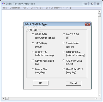
3DEM is a Windows application developed to help you generate terrain animations using different models, such as USGS DEM, GeoTiff DEM, SRTM data, terrain matrix, GLOBE or GTOPO30 tile, LIDAR or XYZ point cloud, as well as Mars MOLA or Mars Polar MOLA.
Rapid installation and classical interface
The setup procedure does not take a long time to finish. As for the interface, 3DEM does not include visually attractive elements, but it is simple to navigate. At startup you can select the DEM file type for generating the terrain animation, by picking an option from the list with the above mentioned models.
Tinker with settings easily
It is possible to view DEM specifications, change the projection, toggle a 3D scene, apply, remove or adjust the map overlay, resize the overhead view, patch missing data, select a smaller area, as well as to view and animate flyby.
When it comes to GPS, you can enter the coordinates using the mouse or transfer GPS points to other locations. Meanwhile, the grid for latitude and longitude can be either shown or hidden, and the measurement unit can be selected between degrees, minutes and seconds, as well as UTM meters. The map image can be saved and printed.
Evaluation and conclusion
We have not come across any issues in our tests, since 3DEM did not freeze, crash or display error notifications. It has a good response time and runs on low CPU and RAM, so it does not hog system resources. Help documentation is available for inexperienced users. All in all, 3DEM proves to be quite a resourceful software utility for helping users generate terrain animations. Too bad it has not been updated for a while.


 Windows XP and above
 View Screenshots(1)
 Comments
 Download


 Similar Software
 Recently Searched
 Software Categories
 Trending Software


 Like Us


