Works on: Windows 10 | Windows 8.1 | Windows 8 | Windows 7 | Windows XP | Windows 2000 | Windows 2003 | Windows 2008 | Windows Vista | Windows 2012 SHA1 Hash: 75d11cf385444b7c3254960e9e45084c60835102 Size: 48.63 MB File Format: exe
Rating: 2.086956521
out of 5
based on 23 user ratings
Downloads: 1156 License: Free
ATS Mapper is a free software by dB Foresight and works on Windows 10, Windows 8.1, Windows 8, Windows 7, Windows XP, Windows 2000, Windows 2003, Windows 2008, Windows Vista, Windows 2012.
You can download ATS Mapper which is 48.63 MB in size and belongs to the software category Accounting and Billing Software. ATS Mapper was released on 2014-11-17 and last updated on our database on 2017-04-26 and is currently at version 1.01.
Thank you for downloading from SoftPaz! Your download should start any moment now. It would be great if you could rate and share:
Rate this software:
Share in your network:
ATS Mapper Description
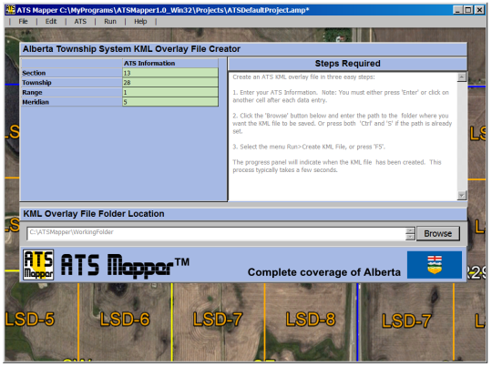
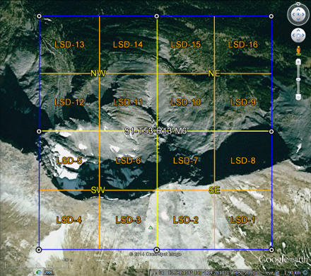
ATS Mapper is a unique application to create KML overlay files of ATS (Alberta Township System) sections. The KML files can be viewed in GIS programs such as Google Earth (TM) or ArcGIS (TM). The overlays include the section outline, quarters, LSDs and the geographic coordinates for the ATS points that define the location of the section. Within seconds ATS Mapper will create your KML file which you can open in Google Earth (TM) or ArcGIS(TM) to see the exact location of the section. See Wiki for information on ATS. You simply enter the legal land description; section, township, range and meridian of the desired location. Within seconds ATS Mapper will create the KML file that you can view in GIS programs such as Google Earth (TM) or ArcGIS (TM). The ATS KML file will include the section outline, quarter sections, LSDs and the geographic coordinates for the 4 corners of the section, the middle east and west coordinates and the middle north and south coordinates, if applicable.
The license for ATS Mapper is PWYW (Pay What You Want). You can try it out for free, then if you are satisfied with it then go to www.atsmapper.com/download and fill in the form with the amount you want to pay. You will receive an invoice from Paypal shortly after that.
Whats new in this version:
Version 1.01 may include unspecified updates, enhancements, or bug fixes.


 Windows XP and above
 View Screenshots(2)
 Comments
 Download


 Similar Software
 Recently Searched
 Software Categories
 Trending Software

 Like Us


