


 Windows XP and above
| Rate this software: | |
| 1866 downloads | |
 View Screenshots(1)
 Comments
 Download


| Rate this software: | |
| Share in your network: |
|

Topodraw:
Import point data from CSV or drawing Import blocks automatically while creating drawing Export codes, point data in different layer selectively Create Total station data from CAD drawing Selectively Auto Connect codes in CAD
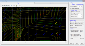
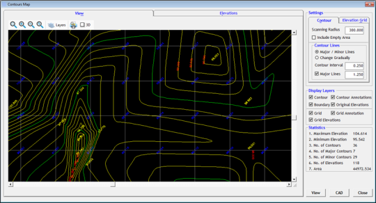
Contours:
Import data from CSV, Excel or CAD for Contour generation Generate Contours directly within CAD Draw Section for any alignment fixed on the Contour Map Generate Contour Area and Contour Volume instantly - Boundary Based / Specific Levels Generate Grid Elevations (Block Levels)
Annotate Contours - Endpoints, Midpoints, Selected Points, Specified Intervals Draw Grid Elevations from existing Contours Detailed Layerisation
Earthwork:
Import data from CSV/CAD and Generate Section Drawings with Earthwork Calculation Generate Earthwork calculation with fixed formation level or between two surfaces Generate interim Earthwork reports during progress of projects Generate detailed quantity calculation (Quantity takeoff) reports either using Tripizoidal method or Block method Generate Elevation grids or Block levels without getting into complicated surface creation Generate Earthwork Calculation reports between given Depth of cut or Depth of Fill Automatic calculation of Optimum Fixed Formation level
Benefits:
Save considerable time while generating drawing from field data. Detailed Layerised Output helps to process the drawing easily Avoid Creating terrain for Contour generation Separately Generate Presentable Quality Smooth contours Quickly Lightweight contours thereby reducing the drawing file size Generate Boundary, Grid Elevation, Grid annotation, Contours, Contour annotation in Single step.
Whats new in this version:
Bug fixed till 14.12.2013.

| $599 | Click the link to buy | Buy |
 Similar Software


 Recently Searched
 Software Categories
 Trending Software

 Like Us


