Works on: Windows 10 | Windows 8.1 | Windows 8 | Windows 7 | Windows XP | Windows 2000 | Windows 2003 | Windows 2008 | Windows Vista | Windows 2012 SHA1 Hash: e22fc38b2ace7f7e3f6254dd6d98dcd3be629f80 Size: 3.21 MB File Format: exe
Rating: 1.956521739
out of 5
based on 23 user ratings
Publisher Website: External Link Downloads: 212 License: Demo / Trial Version
Flares is a demo software by Enviroware and works on Windows 10, Windows 8.1, Windows 8, Windows 7, Windows XP, Windows 2000, Windows 2003, Windows 2008, Windows Vista, Windows 2012.
You can download Flares which is 3.21 MB in size and belongs to the software category Home and Education. Flares was released on 2011-12-28 and last updated on our database on 2017-04-23 and is currently at version 2.1.
Thank you for downloading from SoftPaz! Your download should start any moment now. It would be great if you could rate and share:
Rate this software:
Share in your network:
Flares Description
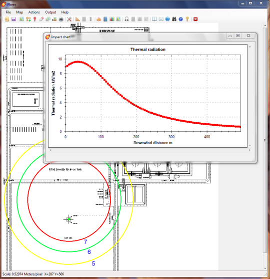
A Windows software for sizing industrial flares, for the evaluation of their thermal and acoustic impact and for the calculation of the flue gas composition. Calculations are made according to the ANSI/API (American Petroleum Industry) Standard 521, fifth edition January 2007 (and its addendum of May 2008), ISO 23251, AP42 and US-EPA methodologies.The main features of the software are:Ability to size (i.e. to calculate the minimum values of height and diameter) subsonic industrial flares according to a specified allowable radiation;Calculation of thermal radiation and noise levels of subsonic and sonic flares;Flame tilting calculated with the Simple approach and with the Brzustowski and Sommer approach;Calculation of the flue gas composition starting from the fuel gas composition;Calculation of the effective stack parameters needed for dispersion modelling (EPA SCREEN3 and TCEQ methodologies);Ability to work with SI (International Standard) and USC (United States Customary) units;Allows to load and georeferentiate raster base maps (automatic georeferentiation if the base map file has an associated world file);Allows to position the stack over the base map;Thermal radiation levels and noise levels are shown at any point moving the mouse over the base map;Plots radiation levels and noise levels over the base map;Stack can be exported in KML format for Google Earth as a 3D cylinder;Thermal radiation levels and noise levels can be exported in KML format for Google Earth.
Where to buy?
Last updated price and discount information 9 years agoupdate now


 Windows XP and above
 View Screenshots(1)
 Comments
 Download


 Similar Software


 Recently Searched
 Software Categories
 Trending Software
 Like Us


