Works on: Windows 10 | Windows 8.1 | Windows 8 | Windows 7 | Windows 2012 SHA1 Hash: 9e35df1e331369474e210cdc293b8e5dd8ba7e8b Size: 936.17 KB File Format: zip
Rating: 2.391304347
out of 5
based on 23 user ratings
Publisher Website: External Link Downloads: 268 License: Demo / Trial Version
Geodaten German Houses is a demo software by C. Killet Software Ing.-gbr and works on Windows 10, Windows 8.1, Windows 8, Windows 7, Windows 2012.
You can download Geodaten German Houses which is 936.17 KB in size and belongs to the software category Personal Finance. Geodaten German Houses was released on 2012-04-06 and last updated on our database on 2017-04-17 and is currently at version 16.1.
Thank you for downloading from SoftPaz! Your download should start any moment now. It would be great if you could rate and share:
Rate this software:
Share in your network:
Geodaten German Houses Description
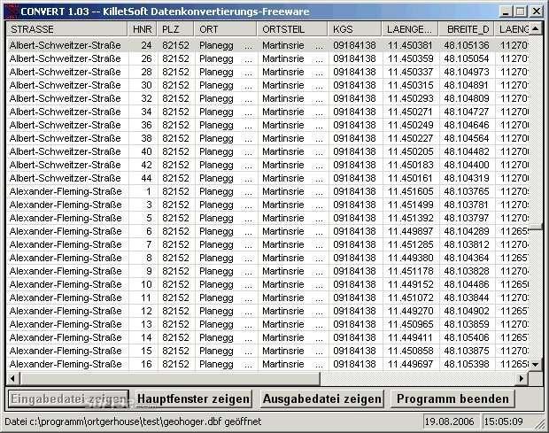
For the area of the Federal Republic of Germany more than 19 million House Coordinates with a coverage of 100% are available. The geo data offered here are in high-precision quality and are present in several coordinate and reference systems (Geographic, UTM, Gauß-Kruger / WGS84, ETRS89, DHDN) . House Coordinates are the cartographically representable positions of buildings, which are defined by their postal addresses. They are also called "Geo Coded Building Addresses". The House Coordinates are the basis for applications, which are developed to assign building's exact positions. The possible field of application is very various. So e.g. own address lists can be enriched with geo references and visualized on suitable map material. The application scope reaches from information systems over navigation services, geo marketing, telecommunications and UTMS based services up to Web applications and tasks of the power authorities and security services. Another point of interest can be the establishing relationships between data derived from different hierarchies and levels. For example, it could be desirable to know to which federal state, administrative district and city a building belongs to. The coordinates of the buildings are present as geographic coordinates, UTM coordinates and Gauss Kruger coordinates. Geographical coordinates in degree notation are particularly suitable well for searches with Google Earth. Here is as an example an Internet URL with coordinates from the "Geo Data German Houses", which can represent the location of Killet Software Ing.-GbR point-exactly: "http://maps.google.com/maps?t = k & ll = 51 . 397363 , 6 . 450883 & spn = 0 . 002 , 0 . 002 " . The first value behind the identifier "ll" (lat / lon) is the geographical latitude, then the geographical longitude follows. The shown URL can be inserted directly into the address field of the browser to represent a map cutout on the screen. The free data converter CONVERT transforms to CSV, SDF, dBase and SQL files.


 Windows 7 and above
 View Screenshots(3)
 Comments
 Download


 Similar Software
 Recently Searched
 Software Categories
 Trending Software


 Like Us


