Works on: Windows 10 | Windows 8.1 | Windows 8 | Windows 7 | Windows 2012 SHA1 Hash: 7b2b407984132d33df68a12032cdb27fbbb15cf8 Size: 465.63 KB File Format: exe
Rating: 2.260869565
out of 5
based on 23 user ratings
Publisher Website: External Link Downloads: 1382 License: Free
Google Earth PhotoTag is a free software by David Tryse and works on Windows 10, Windows 8.1, Windows 8, Windows 7, Windows 2012.
You can download Google Earth PhotoTag which is 465.63 KB in size and belongs to the software category Science CAD. Google Earth PhotoTag was released on 2012-03-14 and last updated on our database on 2017-03-04 and is currently at version 1.26.
Thank you for downloading from SoftPaz! Your download should start any moment now. It would be great if you could rate and share:
Rate this software:
Share in your network:
Google Earth PhotoTag Description
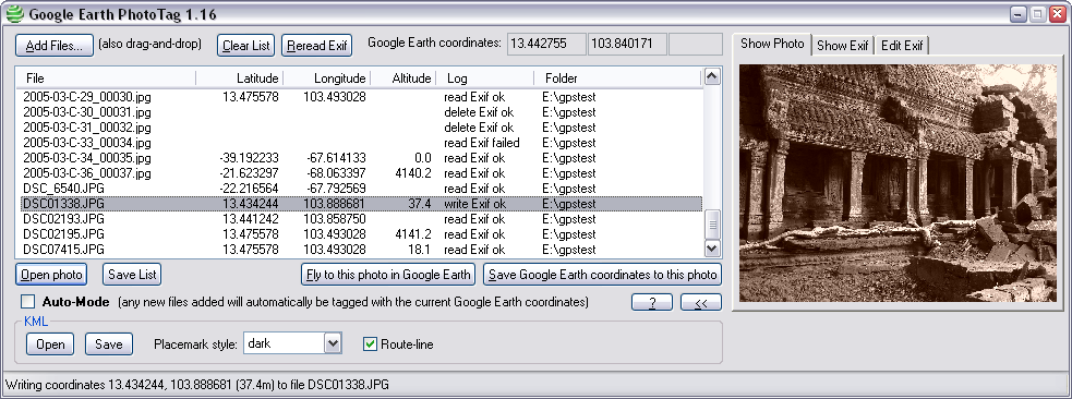
Google Earth PhotoTag is a neat software solution that allows you to add exif data to pictures on your computer and view them in Google Earth.
It's packed with all sort of neat tools that you could use in order to edit data on pictures and save results inside your computer.
Easy-to-use interface with lots of tools
Google Earth PhotoTag doesn't take long to install and it doesn't have a complicated setup that you might need to complete. Before you can actually use all of its features, you'll need to also install Google Earth on your device so that the application can access it.
Browse your computer in order to add pictures or use the drag and drop feature. There's the option to add multiple images to the application and edit them at the same time.
Add or remove exif data from images
Google Earth PhotoTag allows you to add multiple files but only those in .jpeg, .jpg or .phototaglist formats. It automatically displays the latitude, longitude or altitude, but it doesn't read the information at times.
There's the option to manually add it, delete it or copy information to clipboard. It displays a preview inside the interface and you can view them by double clicking on one item. In addition, you can check details and exif inside in a separate section.
Fly to pictures using Google Earth
Once you've checked the coordinates, you can open pictures with Google Earth and view them there. There's also the option to enable the auto-mode, which will automatically tag new added files with the current Google Earth coordinates.
You can adjust the placemark style and enable the option that displays the route-line. Save the KML file when you're done and check them later.
All in all, Google Earth PhotoTag is a very nice application for adding and editing coordinates on pictures and then opening them with Google Earth.


 Windows 7 and above
 View Screenshots(1)
 Comments
 Download


 Similar Software
 Recently Searched
 Software Categories
 Trending Software

 Like Us


