Works on: Windows 10 | Windows 8.1 | Windows 8 | Windows 7 | Windows XP | Windows 2000 | Windows 2003 | Windows 2008 | Windows Vista | Windows 2012 SHA1 Hash: 27d18c7a92d496cc6e3e8a6e2d33fff13ef3d6a6 Size: 480.85 KB File Format: exe
Rating: 2.173913043
out of 5
based on 23 user ratings
Publisher Website: External Link Downloads: 489 License: Demo / Trial Version
Graph Earth is a demo software by Deer Creek Marketing and works on Windows 10, Windows 8.1, Windows 8, Windows 7, Windows XP, Windows 2000, Windows 2003, Windows 2008, Windows Vista, Windows 2012.
You can download Graph Earth which is 480.85 KB in size and belongs to the software category Home and Education. Graph Earth was released on 2012-04-04 and last updated on our database on 2017-04-23 and is currently at version 0.9.
Thank you for downloading from SoftPaz! Your download should start any moment now. It would be great if you could rate and share:
Rate this software:
Share in your network:
Graph Earth Description
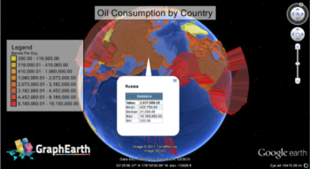
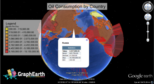
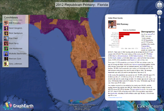
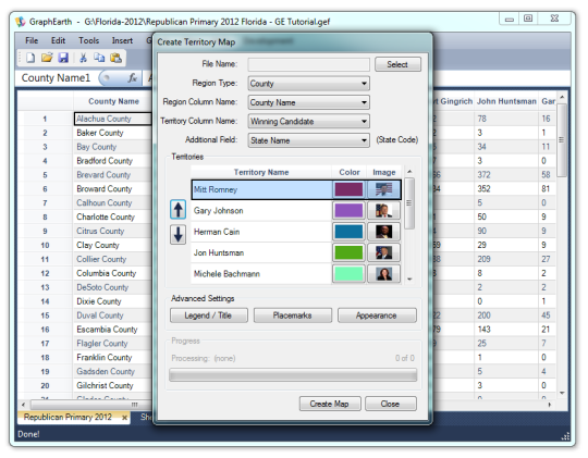
Visualize your data in 3D. Quick, easy and inexpensive. GraphEarth enables marketing and other business professionals to create stunning visual representations of their data, all without the time and costs associated with a full-featured GIS. Create one of a kind deliverables and distribute them to the world, recipients need only install GoogleEarth to view the resulting standards compliant KML/KMZ files. Viewable by Everyone. Graph Earth produces documents in the Google Earth (KML/KMZ) format. Anyone with Google Earth installed can view your graphs by simply downloading this free application. No license of GraphEarth is required. Send your documents by email, post them on the web, anyone can view them. As simple as your favorite spreadsheet application. From the ground-up GraphEarth is designed to work like your favorite business tools. No complex GIS. No Shapefiles. No databases. No coordinate systems. Just import or enter your values and start creating stunning visuals. All the necessary geometry is already included in the application. GraphEarth currently supports visualization by country, state, county, city and zip code, with MSA (Metropolitan Statistical Area) and other regions coming soon. Embed 2D charts in 3D documents. GraphEarth allows you to do more than just "surface level" visualization. Embedded charts are an excellent tool to let your data tell its story. Best of all, the user can simply close the embedded chart bubble when they are done and return the graph to a clean, simple state. No confusing, overlapping polygons here. Since this feature utilizes Google Charts, 2D objects are download only when the user needs them, reducing file sizes and transfer times.
Whats new in this version:
Version 0.9.5:
Where to buy?
Last updated price and discount information 9 years agoupdate now


 Windows XP and above
 View Screenshots(3)
 Comments
 Download


 Similar Software
 Recently Searched
 Software Categories
 Trending Software
 Like Us


