Works on: Windows 10 | Windows 8.1 | Windows 8 | Windows 7 | Windows 2012 SHA1 Hash: 35a9643dc459aafd96438f85cf79d72b4e404c2c Size: 382.74 KB File Format: zip
Rating: 1.956521739
out of 5
based on 23 user ratings
Publisher Website: External Link Downloads: 688 License: Free
Planisphere is a free software by James W Cheek and works on Windows 10, Windows 8.1, Windows 8, Windows 7, Windows 2012.
You can download Planisphere which is 382.74 KB in size and belongs to the software category Home and Education. Planisphere was released on 2016-12-30 and last updated on our database on 2017-04-21 and is currently at version 0.1.
Thank you for downloading from SoftPaz! Your download should start any moment now. It would be great if you could rate and share:
Rate this software:
Share in your network:
Planisphere Description
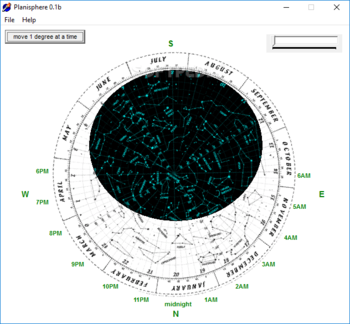
Generally speaking, a planisphere is a hand-held device that enables you to view a map of the night sky along with the planets and stars that are visible during a certain interval of the year.
Planisphere is a lightweight piece of software designed to lend you a hand with creating a start chart so that you can check out how stars move through the night sky and the constellations that are visible at different times of the year.
No installation, but comes with an outdated interface
The setup is as simple as it gets and entails decompressing the archive in any desired location on your hard disk. Upon launch, you are welcomed by a chart of the visible constellations, planets and other astral bodies that are visible during the night every month of the year.
The kit is well-structured and includes the cardinal points along and hours, but it looks rugged and old-school. Nevertheless, let us not forget that the mere idea of planisphere is to allow you to follow the movement of the sky from specific parts of the globe.
Could really use a zoom function
It is worth mentioning that the map provided within the application is quite detailed and crowded. It would have been nice if the app came with a zoom function that enables you to view the constellations, stars and other points of interest in the night sky.
At the same time, it is unclear for which geographic location the map is created for. It would have been helpful if the program allowed you to add the longitude and latitude so that you can create a chart for your precise location.
A simplistic tool that can help you build your start chart
In the eventuality that you want to create a map of the sky so that you can follow the movement of the constellations, planets and other stars that are visible in your area, then perhaps Planisphere could come in handy.


 Windows 7 and above
 View Screenshots(1)
 Comments
 Download


 Similar Software
 Recently Searched
 Software Categories
 Trending Software


 Like Us


