Works on: Windows 10 | Windows 8.1 | Windows 8 | Windows 7 | Windows XP | Windows 2000 | Windows 2003 | Windows 2008 | Windows Vista | Windows 2012 SHA1 Hash: 9dc0dabe596451b98de3f9772c619ad0fe4c3fa2 Size: 5.66 MB File Format: zip
Rating: 2.652173913
out of 5
based on 23 user ratings
Publisher Website: External Link Downloads: 2778 License: Demo / Trial Version
The Ancient Rome Vector Map is a demo software by Euratlas Nussli and works on Windows 10, Windows 8.1, Windows 8, Windows 7, Windows XP, Windows 2000, Windows 2003, Windows 2008, Windows Vista, Windows 2012.
You can download The Ancient Rome Vector Map which is 5.66 MB in size and belongs to the software category Maps and Navigation. The Ancient Rome Vector Map was released on 2006-04-25 and last updated on our database on 2017-04-19 and is currently at version 1.
Thank you for downloading from SoftPaz! Your download should start any moment now. It would be great if you could rate and share:
Rate this software:
Share in your network:
The Ancient Rome Vector Map Description
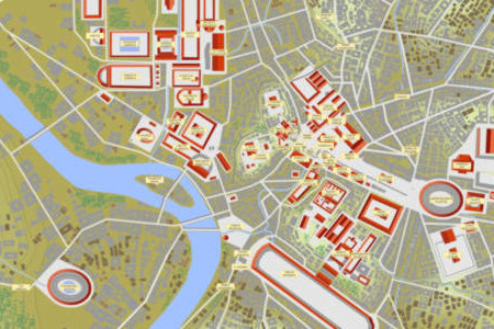
A vector map of ancient Rome in year 100 AD, in Corel Draw 10 and Adobe Illustrator 8 format, with contour lines, public and private buildings, roads, woods, gardens, and labels. The map allows the display of the Seven Hills only with the prehistoric villages existing before the emergence of the city. The map consists of 40 layers or planes which surimposing order, names, fonts, and colors can be changed according to users choice.1) & 2) flumen: blue ground layer + solum: ground plane in which the river Tiber is drawn.3 to 25) 23 contour lines with an approximate interval of 2.5 meters.26) aquulae: small rivers.27) & 28) romulus: the seven original villages, ~8th century BC. + fora: public squares of Rome in year 100.29) & 30) pontes: bridges over the Tiber in year 100. + viae: roads and streets in year 100.31) & 32) aquaeductus: the aqueduct Aqua Claudia. + domus: buildings in brick, concrete or wood.33) & 34) tectatempla: tile roofs of public buildings and temples. + servius: the so-called Servian Wall built ~4th cent. BC.35) & 36) horti: gardens and woods. + scripta: Latin labels for the public buildings and temples.37) & 38) colliscripta: Latin labels for the Seven Hills. + regiones: Latin labels for the Augustan districts.39) & 40) indexbrit: title block in English. + indexfran: title block in French. Layers 27 and 37 have to be used independently of layers 28 to 36 in order to display the Roman campaign before the emergence of Rome.Layer 38 cannot be used together with layer 36 unless the names are moved. This vector map is provided with its English and French licence, with a detailed description of the layers and with a short tutorial on how to simulate depth with Corel Draw or Adobe Illustrator.
Where to buy?
Last updated price and discount information 9 years agoupdate now


 Windows 2000 and above
 View Screenshots(1)
 Comments
 Download


 Similar Software
 Recently Searched
 Software Categories
 Trending Software

 Like Us


