Version: 1 Last Updated: 27 Apr 2017 Release: 20 Oct 2015 Category: Internet > WEB Design
Rate this software:
1186 downloads
View Screenshots(4)
Comments
Download
Liked it? Tell others:
Topo Details
Works on: Windows 10 | Windows 8.1 | Windows 8 | Windows 7 | Windows XP | Windows 2000 | Windows 2003 | Windows 2008 | Windows 98 | Windows ME | Windows NT | Windows Vista | Windows 2012 SHA1 Hash: badce3ad5f3be04063117ebb485bbfea722cf5f3 Size: 774.74 KB File Format: zip
Rating: 2.086956521
out of 5
based on 23 user ratings
Publisher Website: External Link Downloads: 1186 License: Demo / Trial Version
Topo is a demo software by Engineering Solutions and works on Windows 10, Windows 8.1, Windows 8, Windows 7, Windows XP, Windows 2000, Windows 2003, Windows 2008, Windows 98, Windows ME, Windows NT, Windows Vista, Windows 2012.
You can download Topo which is 774.74 KB in size and belongs to the software category WEB Design. Topo was released on 2015-10-20 and last updated on our database on 2017-04-27 and is currently at version 1.
Thank you for downloading from SoftPaz! Your download should start any moment now. It would be great if you could rate and share:
Rate this software:
Share in your network:
Topo Description
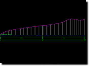
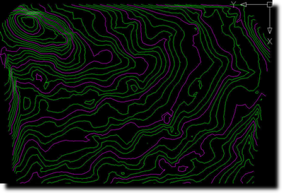
Topo features a series of CAD tools that enables processing of digital landscape, cross-sections and contour lines for land survey works.Topo comes as an AutoCAD plugin and it is not designed to function as self standing software. Please note that VBA Module are required by this add-on, therefore an AutoCAD LT version is not adequate for installing and running this add-on.Some of the Topos key routines include: - Draw a scaled grid for plan plotting - Import points from ASCII (simple text) 3D coordinate file - Export coordinates to ASCII in Cartesian or polar coordinate system - Form the Triangular Irregular Network (TIN) of a survey site - Manual handling and correction tools for TIN elements - Produce analytical area calculations and draw calculation formulas on drawing - Produce a cross section of the landscape - Produce contour lines of the site.Also includes a series of useful CAD tools:- Scaling tools for raster images and 3D objects- A series of text manipulation tools - Measurement tools - 3D object manipulationFuture work on this project will allow an advanced version that allows: - Volume measurements - Road design
Whats new in this version:
Upgraded compatibility with x64 systems and AutoCAD 2014 and newer.On line trial & registration system introduces,
Where to buy?
Last updated price and discount information 6 years agoupdate now


 Windows NT and above
 View Screenshots(4)
 Comments
 Download


 Similar Software
 Recently Searched
 Software Categories
 Trending Software
 Like Us


