Version: 15.1 Last Updated: 14 Jun 2017 Release: 10 Feb 2012 Category: Science CAD
Rate this software:
3281 downloads
View Screenshots(3)
Comments
Download
Liked it? Tell others:
TRANSDAT Details
Works on: Windows 10 | Windows 8.1 | Windows 8 | Windows 7 | Windows XP | Windows 2000 | Windows 2003 | Windows 2008 | Windows 98 | Windows ME | Windows Vista | Windows 2012 SHA1 Hash: bf0b94e04cb34eab17566162e74d484a0fe97770 Size: 2.52 MB File Format: zip
Rating: 2.565217391
out of 5
based on 23 user ratings
Downloads: 3281 License: Demo / Trial Version
TRANSDAT is a demo software by C. Killet Software Ing.-gbr and works on Windows 10, Windows 8.1, Windows 8, Windows 7, Windows XP, Windows 2000, Windows 2003, Windows 2008, Windows 98, Windows ME, Windows Vista, Windows 2012.
You can download TRANSDAT which is 2.52 MB in size and belongs to the software category Science CAD. TRANSDAT was released on 2012-02-10 and last updated on our database on 2017-06-14 and is currently at version 15.1.
Thank you for downloading from SoftPaz! Your download should start any moment now. It would be great if you could rate and share:
Rate this software:
Share in your network:
TRANSDAT Description
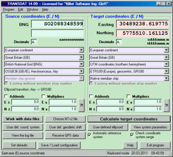
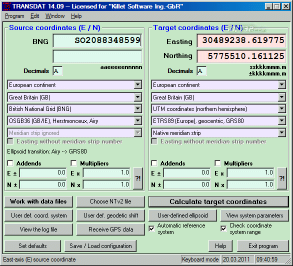
TRANSDAT geosoftware executes coordinate transformations and geodetic datum shifts between many coordinate and reference systems of America, Australasia, Europe, Germany special and world-wide, at high precision and high speed: 1.The current and historical coordinate and reference systems of all countries of the European Union (EU) including the eastern extensions and the systems of non-EU countries. 2. The INSPIRE supported European ETRS89 systems. 3. The US and Canadian State Plane Coordinate Systems (SPCS) on NAD27 and NAD83 and other coordinate systems of the North American continent. 4. The coordinate and reference systems of the Australasian continent. 5. Many coordinate and reference systems of the countries of other continents. 6. World-wide NTv2 grid file supported coordinate transformations. 7. All global coordinate and reference systems. 8. The German coordinate and reference systems of the old and new federal states, the 40 Prussian Soldner Land Registers, the German Lagestatus, and exact reference systems of the German federal states. You will find a complete list of the coordinate and reference systems supported by the program on the web or after downloading the free test version of the program. The NTv2 standard with national grid files is world-wide full supported. Apart from the given world-wide and state-specific systems, your own personal coordinate systems and geodetic reference systems can be defined with Helmert (Bursa / Wolf, ISO 19111) or Molodensky parameters. Calculations can be performed with coordinates entered directly, loaded from files in various formats (Text, CSV, SDF, dBase, ArcShape, ArcGenerate), or passed by batch processing. ArcShape files can be viewed with the internal Shape Viewer. A programmable GPS interface makes it possible to read coordinates from a low-cost GPS antenna. The program can be run on a network, in which case clients are installed automatically. The program has a multilingual interface.
Where to buy?
Last updated price and discount information 8 years agoupdate now


 Windows 98 and above
 View Screenshots(3)
 Comments
 Download


 Similar Software
 Recently Searched
 Software Categories
 Trending Software


 Like Us


