Version: 4 Last Updated: 16 Apr 2017 Release: 22 May 2012 Category: Programming
Rate this software:
201 downloads
View Screenshots(1)
Comments
Download
Liked it? Tell others:
Eye4Software GPS Toolkit for Java Details
Works on: Windows 10 | Windows 8.1 | Windows 8 | Windows 7 | Windows XP | Windows 2000 | Windows 2003 | Windows 2008 | Windows Vista | Windows 2012 SHA1 Hash: fd72499665bee0935cc40db721361954b603f381 Size: 159.27 KB File Format: zip
Rating: 2.304347826
out of 5
based on 23 user ratings
Publisher Website: External Link Downloads: 201 License: Demo / Trial Version
Eye4Software GPS Toolkit for Java is a demo software by Eye4software B.v. and works on Windows 10, Windows 8.1, Windows 8, Windows 7, Windows XP, Windows 2000, Windows 2003, Windows 2008, Windows Vista, Windows 2012.
You can download Eye4Software GPS Toolkit for Java which is 159.27 KB in size and belongs to the software category Programming. Eye4Software GPS Toolkit for Java was released on 2012-05-22 and last updated on our database on 2017-04-16 and is currently at version 4.
Thank you for downloading from SoftPaz! Your download should start any moment now. It would be great if you could rate and share:
Rate this software:
Share in your network:
Eye4Software GPS Toolkit for Java Description
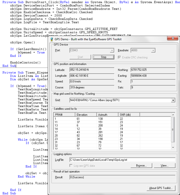
Java toolkit to add coordinate conversion functionality to your Java applications and applets. The toolkit offers functionality to perform map grid and datum transformations: latitude and longitude can be converted to various map grids, like Transverse Mercator (TM), Oblique Mercator, Mercator, Oblique Stereographic, Polar Stereographic, Cassini, Albers Equal Area Conal, Gauss Kruger or Lambert Conformal Conic projection, Lambert Azimuthal Equal Area and Krovak, for instance, to convert the GPS position to UTM or NAD27 / NAD83 State Plane. All map grid parameters can be specified (Scale Factor, False Northing, False Easting, Origin Latitude, Origin Longitude, North Parallel, South Parallel ) allowing you to convert your position to any map grid around.. NADCON, HARN and NTv2 datum conversions are supported. The product can be used to develop software for many operating systems, including: Linux, Windows, Solaris and Android. But also web oriented platforms by using Applets. The software contains more then 5000 map datums and local map grid definitions.
Where to buy?
Last updated price and discount information 9 years agoupdate now


 Windows XP and above
 View Screenshots(1)
 Comments
 Download


 Similar Software
 Recently Searched
 Software Categories
 Trending Software


 Like Us


