Works on: Windows 10 | Windows 8.1 | Windows 8 | Windows 7 | Windows XP | Windows 2000 | Windows 2003 | Windows 2008 | Windows Vista | Windows 2012 SHA1 Hash: c39321e94696adf7315142f82091d41491e2be8c Size: 10.37 MB File Format: exe
Rating: 1.956521739
out of 5
based on 23 user ratings
Downloads: 224 License: Free
GEOPoint is a free software by Gunamoi Software and works on Windows 10, Windows 8.1, Windows 8, Windows 7, Windows XP, Windows 2000, Windows 2003, Windows 2008, Windows Vista, Windows 2012.
You can download GEOPoint which is 10.37 MB in size and belongs to the software category Home and Education. GEOPoint was released on 2013-05-16 and last updated on our database on 2017-04-25 and is currently at version 3.05.
Thank you for downloading from SoftPaz! Your download should start any moment now. It would be great if you could rate and share:
Rate this software:
Share in your network:
GEOPoint Description
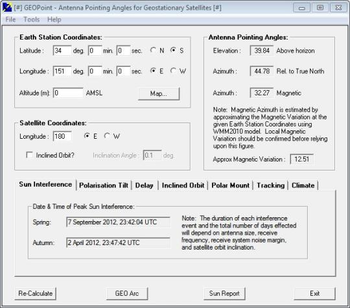
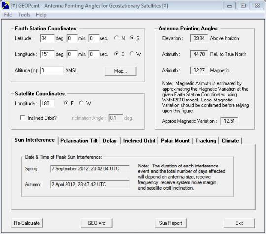
GEOPoint is an easy to use satellite antenna pointing calculator, for geostationary communications satellites. The program also calculates polarization tilt angles, estimates dates and times of annual sun-outage events, calculates antenna G/T, eirp and frequency stability, and estimates path-loss and rain-attenuation based on ITU-R climate models. Features include an easy to use dialog-style user interface for data entry and calculation, entry of earth station location coordinates directly, or by clicking on a world map, select earth station location from a built-in list of world major cities, display of satellite elevation contours on the world map to aid in site selection, entry of latitude and longitude coordinates in D, M, or S format, or as decimal degrees, calculation of pointing angles to a specified satellite for common types of antenna mount, display of azimuth pointing angles relative to true North and relative to local magnetic north, estimation of antenna movement limits for inclined orbit satellites, calculation of polarization tilt angle, loop-back path delay, and required antenna tracking speeds, estimation of the peak dates and times for sun-interference on the receive link, and output of a summary report in HTML format.
Whats new in this version:
Version 3.05 has fixed rounding error where a decimal degrees conversion to D,M,S sometimes resulted in a value of 60 in the minutes box.


 Windows 2000 and above
 View Screenshots(1)
 Comments
 Download


 Similar Software
 Recently Searched
 Software Categories
 Trending Software


 Like Us


