Version: 1.1 Last Updated: 03 Oct 2017 Release: 02 Jun 2006 Category: Science CAD
Rate this software:
3617 downloads
View Screenshots(1)
Comments
Download
Liked it? Tell others:
Terrain for AutoCAD Details
Works on: Windows 10 | Windows 8.1 | Windows 8 | Windows 7 | Windows XP | Windows 2000 | Windows 2003 | Windows 2008 | Windows Vista | Windows 2012 SHA1 Hash: 8c8b7171be25dfdc75350f5eab16cefa4c7ffe91 Size: 10.95 MB File Format: exe
Rating: 2.52173913
out of 5
based on 23 user ratings
Publisher Website: External Link Downloads: 3617 License: Demo / Trial Version
Terrain for AutoCAD is a demo software by Sycode and works on Windows 10, Windows 8.1, Windows 8, Windows 7, Windows XP, Windows 2000, Windows 2003, Windows 2008, Windows Vista, Windows 2012.
You can download Terrain for AutoCAD which is 10.95 MB in size and belongs to the software category Science CAD. Terrain for AutoCAD was released on 2006-06-02 and last updated on our database on 2017-10-03 and is currently at version 1.1.
Thank you for downloading from SoftPaz! Your download should start any moment now. It would be great if you could rate and share:
Rate this software:
Share in your network:
Terrain for AutoCAD Description
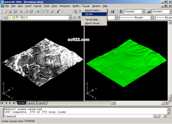
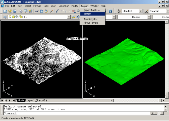
Terrain for AutoCAD is a terrain modeling plug-in for AutoCAD. This plug-in gives AutoCAD the ability to create a terrain mesh from a set of unordered points, lines, polylines and splines. The terrain mesh is created as a Delaunay Triangulation, which is regarded as the best method to create a terrain mesh from unorganized point data. Terrain for AutoCAD can also import a set of points from a text file containing point coordinate data along with point numbers and point descriptions. Terrain for AutoCAD is powered by PointLib, a state of the art terrain modeling library developed by SYCODE.
Terrain for AutoCAD is designed to be extremely user friendly and easy to use. The plug-in adds a new command to AutoCAD called Terrain. The Terrain command has a single parameter called Search Radius. The search radius determines the whether two points can be part of the same triangular face. If the distance between two points is larger than the search radius then they are not connected by a face. A search radius of zero will remove the connectivity constraint and all points will be connected, however far they may be from each other.
Where to buy?
Last updated price and discount information 7 years agoupdate now


 Windows XP and above
 View Screenshots(1)
 Comments
 Download


 Similar Software
 Recently Searched
 Software Categories
 Trending Software

 Like Us


