Version: 3 Last Updated: 14 Jun 2017 Release: 12 Mar 2007 Category: Internet > Chat
Rate this software:
1606 downloads
View Screenshots(1)
Comments
Download
Liked it? Tell others:
US Mileage Charts Details
Works on: Windows 10 | Windows 8.1 | Windows 8 | Windows 7 | Windows XP | Windows 2000 | Windows 2003 | Windows 2008 | Windows Vista | Windows 2012 SHA1 Hash: c4b3d0862a0afaa787520df4aee7f49987e78032 Size: 398.42 MB File Format: zip
Rating: 2.52173913
out of 5
based on 23 user ratings
Publisher Website: External Link Downloads: 1606 License: Demo / Trial Version
US Mileage Charts is a demo software by Winwaed Software Technology Llc and works on Windows 10, Windows 8.1, Windows 8, Windows 7, Windows XP, Windows 2000, Windows 2003, Windows 2008, Windows Vista, Windows 2012.
You can download US Mileage Charts which is 398.42 MB in size and belongs to the software category Chat. US Mileage Charts was released on 2007-03-12 and last updated on our database on 2017-06-14 and is currently at version 3.
Thank you for downloading from SoftPaz! Your download should start any moment now. It would be great if you could rate and share:
Rate this software:
Share in your network:
US Mileage Charts Description
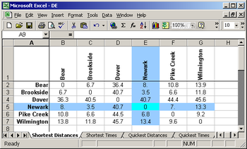
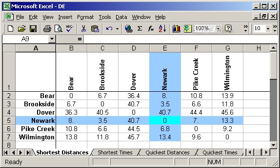
North American Mileage Charts and Tables stored as Excel 2007 workbooks, including travel times and distances for both the fastest and shortest routes. Includes workbooks for pan-North America; all US States; Puerto Rico; and all Canadian Territories (excluding Nunavut which only has one city of sufficient size). Individual charts include all cities with a population of 1000 or more. The pan-North American chart includes the 1000 largest cities in the contiguous US and Canada. This latter chart has 4 million data values (1 million on each of four worksheets). Individual State and Territory charts vary from 2 (Canada's Yukon) to over 800 (Texas) cities.
Charts are available for individual download, or as a combined zip (over 300MB in size). Workbooks use the industry-standard Excel 2007 format. 2007 is required due to the large size of these workbooks. Cities are chosen and located using Geonames.org data.


 Windows XP and above
 View Screenshots(1)
 Comments
 Download


 Similar Software
 Recently Searched
 Software Categories
 Trending Software


 Like Us


