Works on: Windows 10 | Windows 8.1 | Windows 8 | Windows 7 | Windows XP | Windows 2000 | Windows 2003 | Windows 2008 | Windows 98 | Windows ME | Windows NT | Windows Vista | Windows 2012 SHA1 Hash: 2acbd392a063efd7c148cc9a03f7f98aa7c581cd Size: 9.01 MB File Format: exe
Rating: 1.956521739
out of 5
based on 23 user ratings
Publisher Website: External Link Downloads: 377 License: Demo / Trial Version
3D Global Terrain is a demo software by Mc & RENOX and works on Windows 10, Windows 8.1, Windows 8, Windows 7, Windows XP, Windows 2000, Windows 2003, Windows 2008, Windows 98, Windows ME, Windows NT, Windows Vista, Windows 2012.
You can download 3D Global Terrain which is 9.01 MB in size and belongs to the software category Home and Education. 3D Global Terrain was released on 2011-06-16 and last updated on our database on 2017-04-23 and is currently at version 1.2.
Thank you for downloading from SoftPaz! Your download should start any moment now. It would be great if you could rate and share:
Rate this software:
Share in your network:
3D Global Terrain Description
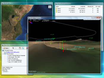
3D Global Terrain is an offline 3D platform that combines NASA imagery generated from Blue Marble project, elevation data from Shuttle Radar Topography Mission and more than 6.5 million of land markers with Cities and Points of Interest into a relatively small but powerful worldwide platform. GTerrain will allow you to visit any place in the world, know the general topography, and load and display Waypoints, Routes and Tracks from many file formats.
Topography and satellite imagery: GTerrain has a full copy of the Blue Marble satellite imagery and the Shuttle Radar Topography Mission (SRTM) Data stored in an off-line database (local copy) allowing you to use GTerrain without Internet connection. Both Blue Marble and the SRTM have a fixed resolution of ~450mts per pixel, in order to maintain a relatively low hard-disk space requirement of ~3GB. This important feature will give you the possibility to use 3D Global Terrain in field applications (using it on a Notebook on the road).
Where to buy?
Last updated price and discount information 9 years agoupdate now


 Windows NT and above
 View Screenshots(1)
 Comments
 Download


 Similar Software


 Recently Searched
 Software Categories
 Trending Software

 Like Us


